Stick to the Facts
Add Nbsla.ca as a Preferred Source on Google to see more of our stories in your search results.
Canadians hoping for steady spring warmth are instead preparing for a dramatic return of winter-like weather as late-season snow, powerful winds, and plunging temperatures spread across several provinces this week. From British Columbia’s mountain regions to the Prairies and parts of Ontario, Quebec, and Labrador, meteorologists are tracking a surge of Arctic air that is expected to create dangerous travel conditions, frost concerns, and significant snowfall in some areas.
The unusual weather pattern arrives just days before the May long weekend, a period that traditionally signals the unofficial start of summer activities across the country. Instead of sunshine and mild temperatures, many communities could wake up to snow-covered landscapes and severe storm conditions.
Arctic Air Mass Triggers Rare May Snowfall Threat
Forecasters say the return of winter conditions is being driven by an intense push of cold Arctic air colliding with active storm systems moving across Canada. The combination is creating the perfect setup for widespread instability and snowfall in regions that would normally be experiencing spring warmth by mid-May.
Meteorologists note that the current pattern resembles conditions more commonly seen in March or early April rather than the second half of May. The cold air is expected to sweep southward through western and central Canada before impacting parts of eastern provinces later in the week.
As temperatures rapidly drop, rain is expected to transition into snow across elevated terrain and northern communities. Some regions could see accumulating snow significant enough to disrupt transportation and outdoor plans.
Southern British Columbia Faces Sharp Temperature Drop
Southern British Columbia is forecast to experience one of the most dramatic weather reversals in the country. After a prolonged stretch of warmer-than-normal conditions, temperatures are expected to tumble as the cold front pushes into the province.
Communities that recently enjoyed spring sunshine may soon see chilly daytime highs, strong winds, and periods of rain mixed with snow at higher elevations. The abrupt shift is likely to catch many residents off guard, especially those who have already begun seasonal outdoor activities.
Weather experts say the cooldown could persist for several days, delaying the region’s transition into stable spring weather.
Freezing Levels Expected to Fall Below 2000 Metres
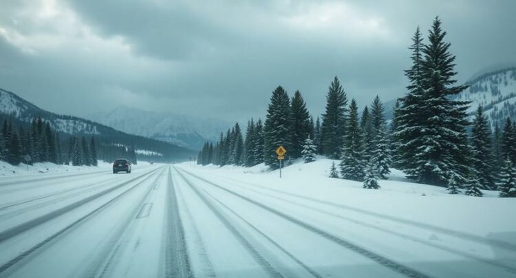
One of the key concerns in British Columbia is the rapidly lowering freezing level. Forecast models indicate freezing levels could dip below 2000 metres, allowing snow to accumulate across several mountain regions.
Drivers traveling through mountain highways and passes may encounter slippery conditions, reduced visibility, and fresh snowfall. Recreational areas in higher terrain could also see a return to winter-like scenery despite the advancing calendar.
The colder air mass is expected to create particularly hazardous conditions overnight and during early morning hours when temperatures reach their lowest levels.
Snowfall Forecast for Coastal, Kootenay, and Rocky Mountain Regions
Snow is forecast across several mountain zones in British Columbia, including the Coastal Mountains, the Kootenays, and the Rocky Mountains. These regions are expected to receive the heaviest snowfall totals during the current weather system.
Some higher elevations could accumulate substantial amounts of snow before the system weakens later in the week. Travelers heading toward mountain destinations are being urged to prepare for rapidly changing conditions.
The late-season snowfall is another reminder that winter weather hazards can persist well into spring across Canada’s mountainous terrain.
Major Spring Storm Targets Alberta
Alberta is bracing for one of the most significant weather events of the season as a powerful spring storm develops across the province. Forecasters warn that damaging winds, heavy rainfall, and accumulating snow could all impact different regions simultaneously.
Wind gusts approaching 100 km/h are possible in exposed areas, raising concerns about difficult driving conditions and localized power outages. Heavy precipitation bands are also expected to intensify as the storm system strengthens.
Northern parts of Alberta may receive more than 20 centimetres of snowfall, particularly in regions where colder air remains firmly in place. Wet, heavy snow combined with strong winds could create dangerous travel conditions and reduced visibility.
Rain, Snow, and Wind Create Multi-Hazard Situation
The storm’s complexity is creating a wide range of hazards across Alberta. Southern areas may experience heavy rain and strong wind, while northern communities face blizzard-like conditions and accumulating snow.
Meteorologists say rapidly changing temperatures will determine whether precipitation falls as rain or snow in some areas. This transition zone may shift quickly, making forecasts especially challenging.
Emergency officials are encouraging residents to monitor updated forecasts and prepare for sudden weather changes throughout the week.
Prairie Provinces Prepare for Another Blast of Winter
The Prairies are also expected to experience colder temperatures and periods of snow as the Arctic air mass pushes eastward. Saskatchewan and Manitoba could see a mix of rain, freezing rain, and wet snow depending on local temperatures.
The return of winter conditions comes after several regions had already begun agricultural preparations for the spring growing season. Farmers are closely watching overnight lows as frost and freezing temperatures threaten early crop development.
Travel conditions may also deteriorate quickly in areas experiencing heavier snowfall or strong winds.
Frost Advisories Issued for Eastern Ontario and Western Quebec
While western Canada deals with snowstorms, eastern Ontario and western Quebec are facing a different cold-weather threat. Frost advisories have been issued for several communities as overnight temperatures are expected to drop near or below the freezing mark.
Gardeners and agricultural producers are being warned that sensitive plants and crops could suffer damage if protective measures are not taken. The cold nights are especially concerning because many regions had already experienced a period of warmer spring temperatures that encouraged early growth.
The risk of frost is expected to continue until the Arctic air mass gradually weakens and temperatures recover later in the week.
Cold Nights Could Impact Early Growing Season
Experts say the timing of the cold snap may create problems for fruit trees, vegetable gardens, and early-season crops. Tender vegetation that has already emerged could be vulnerable to freezing temperatures.
Residents are being encouraged to cover plants overnight or bring potted vegetation indoors where possible. Agricultural communities will continue monitoring forecasts closely for any additional frost warnings.
Labrador and Northern Regions Could Also See Snowfall
Labrador and other northern regions are also expected to experience snowfall as colder air spreads across eastern Canada. While snow in these areas during May is not unheard of, the intensity and reach of the current weather pattern are drawing attention from meteorologists.
Some communities could experience accumulating snow alongside gusty winds and sharply colder temperatures. The system may also bring periods of freezing rain in isolated areas.
Forecasters say the unsettled pattern could continue through much of the week before conditions slowly begin to moderate.
British Columbia Still Battling Drought Despite Cooler Weather
Ironically, even with cooler temperatures and incoming precipitation, parts of British Columbia continue to struggle with drought concerns. Many regions have experienced prolonged dry conditions over recent months, leaving water supplies and ecosystems under stress.
Meteorologists say the incoming storm systems may provide some temporary relief, but they are unlikely to fully reverse long-term moisture deficits. Snowfall in mountain regions could help improve snowpack levels slightly, though experts caution that broader drought issues remain serious.
Officials continue encouraging residents to conserve water as dry conditions persist in several areas.
Victoria Day Weekend Forecast Looking Unsettled
The timing of the late-season cold outbreak is especially frustrating for Canadians planning outdoor activities for the Victoria Day long weekend. Camping trips, cottage travel, and outdoor gatherings could all be affected by colder temperatures and lingering storm activity.
Although some regions may begin to recover by the weekend, forecasters warn that conditions are likely to remain cooler than seasonal averages across large portions of the country.
Meteorologists say Canadians should prepare for rapidly changing conditions and continue checking local forecasts as the storm systems evolve over the coming days.