Stick to the Facts
Add Nbsla.ca as a Preferred Source on Google to see more of our stories in your search results.
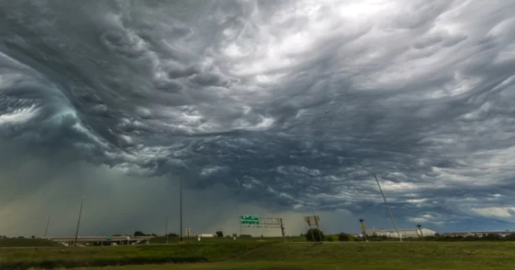
Residents across Simcoe County are being urged to stay weather-aware this weekend as Environment Canada has issued a severe thunderstorm watch for much of the region. While Saturday is expected to begin with warm temperatures, sunshine, and summer-like conditions, meteorologists warn that the weather could quickly take a dangerous turn later in the day.
The national weather agency is forecasting the potential development of strong thunderstorms capable of producing damaging wind gusts, large hail, heavy rainfall, and lightning. The changing weather pattern means that anyone planning outdoor activities, beach visits, boating trips, sporting events, or family gatherings should closely monitor forecasts and be prepared to seek shelter if conditions worsen.
The warning comes as southern Ontario experiences a surge of warm and humid air, creating the perfect environment for thunderstorm development. Although many residents may welcome the summer warmth, weather experts say the unstable atmosphere could fuel severe storms capable of causing disruptions throughout the region.
Environment Canada Issues Severe Thunderstorm Watch
What the Weather Alert Means
A severe thunderstorm watch is issued when atmospheric conditions are favourable for the development of severe thunderstorms. It does not necessarily mean a storm is already occurring, but rather that residents should remain alert because severe weather may develop with little warning.
According to Environment Canada, the Simcoe County region faces the possibility of thunderstorms and scattered showers from Saturday afternoon through the evening hours. Weather conditions are expected to become increasingly unstable as daytime heating combines with moisture-rich air moving into the area.
Forecasters note that severe thunderstorms can form rapidly and may produce dangerous conditions over a short period of time. Residents are encouraged to keep track of weather updates and be prepared to change plans if storms begin to develop.
Areas Potentially Impacted
The severe thunderstorm watch covers much of the Simcoe County region, where communities could experience varying degrees of storm activity throughout the day. While not every area will necessarily see severe weather, any thunderstorm that develops has the potential to intensify quickly.
Local authorities and emergency officials often advise residents to remain cautious during severe weather watches, particularly when planning activities that take place near open water, parks, beaches, or large outdoor venues.
Strong Winds Could Reach Up to 90 Kilometres Per Hour
Damaging Wind Gusts Pose Significant Risks
One of the primary concerns associated with Saturday’s weather system is the potential for powerful wind gusts reaching up to 90 kilometres per hour.
Winds of this magnitude can create hazardous conditions for both residents and travellers. Loose outdoor furniture, umbrellas, tents, and other unsecured items may become airborne during strong gusts. Tree branches could break, and in some cases entire trees may be uprooted if soil conditions are sufficiently saturated.
Motorists should exercise caution, particularly on highways and open roads where sudden crosswinds can affect vehicle stability. Drivers of larger vehicles, including transport trucks, recreational vehicles, and trailers, may experience additional challenges during periods of intense wind.
Potential Impact on Boaters and Beachgoers
People planning to spend time on lakes or waterways should be especially cautious. Thunderstorms can create rapidly changing conditions on the water, with strong winds generating dangerous waves and reducing visibility.
Boaters are encouraged to monitor weather conditions continuously and return to shore immediately if dark clouds or thunder become evident. Beaches and waterfront locations may also become unsafe if lightning approaches.
Large Hail Could Accompany Severe Thunderstorms
Hail the Size of a Toonie Possible
Environment Canada has also warned that some storms could produce large hail, potentially reaching the size of a Canadian toonie.
Hail of this size can cause considerable damage to vehicles, windows, roofing materials, siding, and outdoor property. Individuals are encouraged to move vehicles into garages or covered areas whenever possible if severe weather approaches.
Large hailstones can also pose a risk of injury to people and animals caught outdoors. Weather experts advise seeking shelter inside a sturdy building as soon as thunder is heard or severe weather is observed nearby.
Agricultural Concerns
The threat of hail is also significant for agricultural communities throughout the region. Crops can sustain damage when struck by large hailstones, particularly during active growing periods.
Farmers and agricultural operators may face challenges if storms become severe enough to affect fields, greenhouses, or farm infrastructure. Although the extent of any damage will depend on storm intensity and location, hail remains one of the most destructive weather hazards associated with summer thunderstorms.
Risk of Power Outages and Property Damage
Electrical Infrastructure May Be Vulnerable
Strong winds, lightning strikes, and falling tree branches can all contribute to power outages during severe thunderstorms. Utility crews often prepare for increased service calls when weather alerts are issued, especially when forecasts include damaging wind potential.
Residents are encouraged to charge mobile devices, ensure flashlights are operational, and have emergency supplies readily available in case power interruptions occur.
Although not every storm results in outages, severe thunderstorms frequently create localized disruptions that can affect homes and businesses for several hours.
Protecting Homes and Property
Homeowners can reduce potential storm-related damage by securing outdoor furniture, closing windows, and ensuring drainage systems are clear before storms arrive.
Those with valuable outdoor equipment may wish to move items indoors or under protective shelter. Taking preventative measures before storms develop can significantly reduce the likelihood of weather-related damage.
Warm Temperatures and High Humidity Create Summer-Like Conditions
Temperatures Climb Into the Mid-20s
Before storms arrive, Saturday is expected to deliver classic summer weather across Simcoe County. Environment Canada forecasts a mix of sun and cloud with daytime temperatures reaching approximately 26 degrees Celsius.
Combined with elevated humidity levels, conditions are expected to feel closer to 29 degrees Celsius during the afternoon. The warmth and moisture in the atmosphere are key ingredients contributing to thunderstorm development later in the day.
For many residents, the day may begin with ideal conditions for outdoor recreation. However, meteorologists stress that weather conditions can change quickly once thunderstorms begin forming.
Heat and Humidity Fuel Atmospheric Instability
Warm, humid air contains substantial energy that can be released when thunderstorms develop. As the atmosphere becomes increasingly unstable, rising air currents can support stronger storm cells capable of producing severe weather.
This combination of heat and moisture often serves as a warning sign that thunderstorms may intensify rapidly during afternoon and evening hours.
High UV Levels Prompt Sun Safety Reminder
Very High UV Index Expected
In addition to thunderstorm concerns, Environment Canada is warning residents about elevated ultraviolet radiation levels.
The UV index is expected to reach 7, which falls within the very high category. Such conditions increase the risk of sunburn and skin damage, particularly during peak afternoon hours.
People spending time outdoors are encouraged to take appropriate precautions, including applying sunscreen, wearing protective clothing, and seeking shade when possible.
Outdoor Enthusiasts Should Prepare for Multiple Weather Risks
Saturday presents an unusual combination of weather hazards. Early in the day, residents may need sun protection due to strong UV exposure. Later, many could find themselves seeking shelter from thunderstorms, lightning, and potentially severe weather.
This dramatic shift highlights the importance of monitoring forecasts throughout the day rather than relying solely on morning conditions.
Thunderstorm Risk Continues Into Saturday Night
Storm Activity May Persist After Sunset
The risk of showers and thunderstorms is expected to continue into Saturday evening and overnight hours. While temperatures will gradually cool, unsettled weather conditions may linger across parts of the region.
Environment Canada forecasts an overnight low near 14 degrees Celsius. Although this remains relatively mild, residents should remain aware that thunderstorms can continue after dark.
Nighttime storms can be particularly hazardous because lightning, heavy rain, and strong winds may be more difficult to see approaching.
Evening Events Could Face Weather Disruptions
Outdoor concerts, sporting events, festivals, and social gatherings scheduled for Saturday evening may encounter interruptions if thunderstorms move through the area.
Organizers and attendees are encouraged to review contingency plans and remain informed about changing weather conditions.
Dramatic Cool Down Arrives on Sunday
Temperatures Drop Nearly 10 Degrees
Following Saturday’s warm and humid conditions, a significant weather change is expected on Sunday.
Forecasters predict daytime temperatures will reach only 17 degrees Celsius, representing a drop of approximately nine degrees compared with Saturday’s highs. The cooler air mass will provide relief from humidity but will also create a noticeably different feel across the region.
Many residents who enjoy Saturday’s summer-like warmth may find Sunday considerably cooler and more typical of seasonal June weather.
Increased Cloud Cover and Continued Rain Chances
Clouds are expected to increase throughout Sunday, with additional opportunities for rain showers and thunderstorms.
Although severe weather may become less widespread than on Saturday, unsettled conditions could continue to affect outdoor plans. Residents should remain prepared for periods of rain and changing skies throughout the day.
The cooler temperatures combined with increased cloud cover will create a stark contrast to the sunny conditions expected only 24 hours earlier.
Chilly Sunday Night Ends the Weekend
Single-Digit Temperatures Return
By Sunday evening, temperatures are forecast to fall even further, dropping to around 8 degrees Celsius overnight.
The cool night air will mark a dramatic end to a weekend characterized by rapidly changing weather conditions. Residents who spent Saturday in shorts and sunglasses may find themselves reaching for jackets and long pants by Sunday night.
The arrival of cooler temperatures signals the passage of the weather system responsible for Saturday’s thunderstorm threat.
Safety Remains the Top Priority
Remember the Lightning Safety Rule
Environment Canada continues to emphasize one of the most important thunderstorm safety messages: when thunder roars, go indoors.
Lightning remains one of the most dangerous aspects of thunderstorms and can strike several kilometres away from a storm’s centre. Every year, Canadians are injured or killed by lightning strikes, many of which occur during outdoor recreational activities.
Anyone who hears thunder should immediately move into a substantial building or hard-topped vehicle and remain sheltered until at least 30 minutes after the last rumble of thunder.
Stay Informed Throughout the Weekend
As weather conditions evolve, residents are encouraged to monitor forecasts, weather alerts, and official updates from Environment Canada. Severe thunderstorms can develop rapidly, and staying informed can help individuals make safer decisions for themselves and their families.