Stick to the Facts
Add Nbsla.ca as a Preferred Source on Google to see more of our stories in your search results.
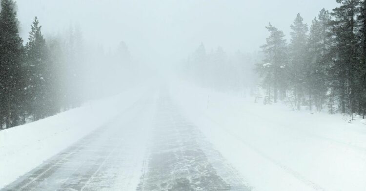
The dangerous i-5 snow wind closure threat is rapidly becoming one of the biggest weather stories across the Western United States this weekend as a powerful late-season Pacific storm unleashes heavy mountain snow, extreme winds, whiteout travel conditions, and possible highway shutdowns from Washington State all the way to Arizona.
Drivers across California, Oregon, Washington, Wyoming, Colorado, Utah, Idaho, Montana, Nevada, and Arizona are now facing serious travel dangers as the storm intensifies. Forecasters warn that the combination of heavy snowfall and hurricane-force wind gusts could trigger major i-5 snow wind closure concerns near Tejon Pass while other key interstates including I-70, I-80, I-15, and I-10 also face hazardous conditions.
Meteorologists say this is not a typical spring storm. It is a full-scale Western weather event already producing dangerous conditions across mountain passes, deserts, and major freight corridors.
I-5 Snow Wind Closure Concerns Grow at Tejon Pass
One of the biggest concerns is the growing risk of an i-5 snow wind closure near California’s Tejon Pass, also known as the Grapevine. This critical transportation corridor connects Southern California with Central California and carries thousands of vehicles daily, including commercial trucks and freight traffic.
High Wind Warnings remain active for the area with gusts expected to reach 60 mph overnight into Sunday. These winds are strong enough to overturn high-profile vehicles, especially RVs, box trucks, trailers, and vehicles carrying rooftop cargo.
The i-5 snow wind closure threat comes as strong crosswinds combine with colder air moving into higher elevations. Even if snowfall totals remain limited at lower elevations, the combination of blowing dust, reduced visibility, and sudden gusts could make travel extremely dangerous.
Transportation officials are closely monitoring the situation because Tejon Pass has a long history of weather-related shutdowns during severe storms.
Massive Storm Impacts Stretch Across 10 States
This single weather system is now affecting an enormous section of the western United States. Active weather alerts currently stretch across:
- California
- Oregon
- Washington
- Montana
- Wyoming
- Idaho
- Utah
- Colorado
- Nevada
- Arizona
The scale of this storm is extraordinary for mid-May. While many lower elevations are already experiencing spring temperatures, winter conditions are returning aggressively to mountain regions.
The storm’s two major threats are:
- Heavy mountain snowfall
- Damaging high winds
Together, these hazards are increasing fears of widespread travel disruptions, including possible i-5 snow wind closure developments and chain-control restrictions across multiple states.
Up to 20 Inches of Snow Forecast in the Tetons
The northern Rockies are expected to take the biggest snowfall hit from this powerful system.
Forecasters say the Teton Range in Wyoming could receive up to 20 inches of snow through Sunday night. Higher elevations in Yellowstone National Park and Grand Teton National Park are already seeing accumulating snowfall as temperatures plunge.
Yellowstone National Park and Grand Teton National Park are already experiencing dangerous winter-like conditions despite the late spring season.
Heavy snowfall is also spreading across:
- Washington Cascades
- Oregon Cascades
- Western Montana
- Idaho mountain passes
- Colorado Rockies
- Utah mountain ranges
- Southwest Wyoming
Forecasters warn the snow totals could increase further if the storm slows down.
Winter Storm Warnings Expected Within Hours
Weather Prediction Center data now shows more than an 80 percent probability that official Winter Storm Warning criteria will be met in parts of the Mountain West.
That means formal warnings are expected soon for:
- Western Colorado
- Northern Utah
- Southwest Wyoming
- Northwestern Wyoming
- Western Montana
Meteorologists say warning issuance is now considered “a matter of hours.”
The highest probabilities are centered near the Colorado Rockies and Utah mountain corridors where snowfall rates may become intense Monday into Tuesday.
I-70 and I-80 Could See Major Shutdowns
While the i-5 snow wind closure risk is grabbing attention in California, other interstate corridors may also face severe travel disruptions.
I-70 Across Colorado
Interstate 70 through the Colorado Rockies could become extremely dangerous as snow intensifies.
Key trouble spots include:
- Vail Pass
- Eisenhower Tunnel
- Loveland Pass region
Drivers should prepare for:
- Chain laws
- Reduced visibility
- Spinouts
- Avalanche mitigation delays
- Full highway closures
I-80 Across Southern Wyoming
Interstate 80 is another major concern. This highway frequently shuts down during powerful spring storms because of blowing snow and severe crosswinds.
Officials warn that conditions could deteriorate rapidly if snowfall combines with gusty winds.
Dangerous Wind Zones Expanding Across California and Arizona
The storm’s wind threat is becoming just as serious as the snowfall threat.
Owens Valley and Eastern Sierra
The strongest wind warning currently active in the country is centered around Owens Valley and the Eastern Sierra.
Wind gusts could reach 70 mph from Sunday into Monday.
Areas near Bishop and US 395 are especially vulnerable to:
- Dust storms
- Reduced visibility
- Falling debris
- Dangerous driving conditions
I-10 at San Gorgonio Pass
Interstate 10 east of Los Angeles is expected to see gusts approaching 65 mph Sunday.
The San Gorgonio Pass is already known for dangerous wind tunnels affecting commercial traffic.
I-15 Between Los Angeles and Las Vegas
Strong desert winds could create hazardous driving conditions on I-15 through the Mojave Desert.
Forecasters say gusts may reach 55 to 60 mph.
Hoover Dam and Lake Havasu Region
The Arizona-Nevada-California tri-state region near Hoover Dam, Bullhead City, and Lake Havasu is also under High Wind Warnings.
Travelers may encounter severe crosswinds through Monday morning.
Hoover Dam and Lake Havasu City could experience some of the strongest desert wind impacts from this storm.
Snow Already Falling in Washington and Oregon
This storm is not a future forecast anymore. Conditions are already deteriorating in the Pacific Northwest.
Snow showers are currently active across:
- Washington Cascades
- Olympic Mountains
- Oregon mountain passes
Forecasts call for 4 to 8 inches of snow above 4,000 feet through Sunday morning.
Important travel routes already impacted include:
- Snoqualmie Pass on I-90
- Stevens Pass on US 2
- White Pass on US 12
Snoqualmie Pass is expected to remain one of the most heavily monitored travel corridors during the storm.
Why the I-5 Snow Wind Closure Threat Is So Serious
The i-5 snow wind closure situation is especially dangerous because Interstate 5 through Tejon Pass is one of the busiest trucking corridors in the western United States.
When strong crosswinds develop there, rollover accidents become common. High-profile vehicles are particularly vulnerable.
Officials are warning drivers not to underestimate the danger simply because it is May. Late-season storms often catch travelers unprepared because many drivers have already switched to summer tires and removed winter emergency gear.
The combination of:
- High winds
- Sudden temperature drops
- Blowing debris
- Mountain snow
- Reduced visibility
can quickly create conditions severe enough to justify an i-5 snow wind closure.
Driver Safety Warnings Issued Across the West
Officials are urging travelers to reconsider mountain and desert travel plans this weekend.
Key recommendations include:
- Avoid unnecessary mountain travel
- Carry tire chains
- Check tire pressure before climbing into colder elevations
- Avoid cruise control on snow or slush
- Increase following distance significantly
- Monitor live highway conditions before departure
Drivers of RVs, trailers, campers, and commercial trucks are being strongly advised to avoid exposed highway corridors during peak wind periods.
The Storm Could Continue Into Tuesday
Forecasters expect the system to continue impacting the West through early next week as colder air pushes deeper into the Rockies.
Additional snowfall accumulation remains possible in:
- Colorado
- Utah
- Wyoming
- Montana
- Idaho
Meanwhile, wind threats may continue across Southern California deserts and parts of Arizona into Monday.
The developing situation means the i-5 snow wind closure threat and other highway shutdown risks could evolve quickly over the next 24 to 48 hours.